Overview
Earthquakes are one of the most powerful natural forces on earth and regularly affect
people around the world. Earthquakes can have a range of magnitudes with the strongest
having devastating consequences for the areas where they are centered, nearby areas,
and even some far away in the case of earthquake-gen erated tsunamis.
Most earthquakes are quite small but are not readily felt. Larger and more violent
earthquakes are those that occur in a release of energy as the plates slide past
or collide into one another.
Large earthquakes can focus on the boundaries where two plates meet, but they are
not limited to these areas. As the plates move, fractures in the earth's crust develop
and earthquakes are often located on them. These fractures are referred to as faults,and
all generate earthquakes when they move.
Cause & Impacts
The most damaging earthquakes happen when the blocks of rock become locked together
due to the intense friction created when they move. As they continue attempting
to move once they are locked, pressure continues to build until it has enough energy
to move the rock and the blocks move, creating an earthquake. The point where the
energy is released is called the focus and the focal depth is the depth beneath
the earth's surface where the energy release originates. The epicenter is another
term used in studying earthquakes and this is the point on the earth's surface directly
above the focus. From here, the energy released spreads out in rings moving across
the surface - not unlike those caused when a rock hits still water. In addition
to the main shaking created by an earthquake, there are often foreshocks and aftershocks.Foreshocks
generally increase in magnitude leading to the main earthquake, whereas aftershocks
happen after the main event and decrease in strength. Once an earthquake finishes
its movement, its magnitude (strength) is determined with the Richter scale measures
the energy released by an earthquake while the Mercalli scale measures the felt
or observed intensity at a particular location.
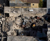
The impacts of earthquakes vary based on their energy and intensity. The strongest
earthquakes that occur can result in ground rupture, causing damage to bridges,
dams, roads, railroad tracks, and the foundations of buildings. They can also cause
landslides and avalanches as a result of the shaking. Intense shaking can also cause
liquification of ground built on landfill when water mains break. The shaking of
an earthquake is increased in areas of landfill.
Another major cause of damage is the fires that ignite when power lines fall and
gas lines rupture. In addition, undersea earthquakes can generate tsunamis that
are capable of traveling great distances from the epicenter and cause significant
damage to coastal communities. In an effort to reduce the impacts of earthquakes,
areas prone to them have taken steps to retrofit buildings and educate citizens
(in schools and the media for example) on what they should do when an earthquake
occurs. Knowledge of what to do and always being prepared for an earthquake is the
best way to reduce injuries, deaths, and damage to cities and towns when they occur.
Seismic Hazard in West Bengal
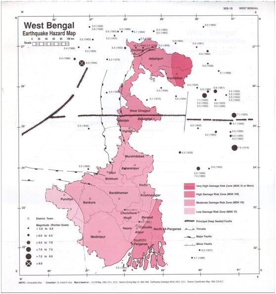
The seismic hazard map of India was updated in 2000 (6) by the Bureau of Indian
Standards (BIS). There are no major changes in the zones in West Bengal with the
exception of the merging of Zones I and II in the 1984 BIS map. Western sections
of the northern districts of Jalpaiguri and Kooch Bihar lie in Zone V. The remaining
parts of these two districts, along with the districts of Darjeeling, Uttar Dinajpur,
Dakshin Dinajpur, Maldah, 24 North Parganas and 24 South Parganas lie in Zone IV.
The rest of the state along with the city of Kolkata, lies in Zone III. Since the
earthquake database in India is still incomplete, especially with regards to earthquakes
prior to the historical period (before 1800 A.D.), these zones offer a rough guide
of the earthquake hazard in any particular region and need to be regularly updated
Largest Instrumented Earthquake in West Bengal
15 April 1964 - Sagar Island, West Bengal, Mb 5.2 (4). 21.600 N, 88.700 E,
D=036.0 kms, OT=08:35:27 UTC (4) Felt in southern West Bengal and eastern Orissa
including at Kolkata and Hugli. Damage in areas near the epicentre such as at Contai
and Diamond Harbour. The maximum intensity in Kolkata was V.
Statistical Data of Earthquakes in West Bengal
|
Date of Occurence
|
Location
|
Position
|
Magnitude
|
Description
|
|
23 June 1976
|
South of the Sunderbans, West Bengal
|
21.180 N, 88.620 E
|
Mb 5.0 (4), D=050.0 kms, OT=15:38:42
|
This earthquake was located in the Bay of Bengal off the Ganga Delta.
|
|
19 November 1980
|
Gangtok area, Sikkim
|
27.400 N, 88.800 E
|
Ms 6.1 (4),D=047.0 kms, OT=19:00:45
|
8 people injured and damage in Gangtok. Felt throughout eastern India, Bangladesh,
Bhutan and Nepal (7).
|
|
26 March 1981
|
Chingrakhali-Bhairabnagar area, West Bengal
|
21.180 N, 88.620 E
|
Mb 4.9 (4),OT=02:47:10
|
This earthquake was located along the India-Bangladesh border to the east of Canning,
West Bengal.
|
|
12 June 1989
|
Sunderbans, Bangladesh
|
21.861 N, 89.763 E
|
Mw 5.7 (7), D=006.0 kms, OT=00:04:09
|
1 person was killed and 100 injured in the Banaripara area of Bangladesh. Felt in
much of eastern Bangladesh including at Chittagong and Rangpur. It was also felt
in Meghalaya, India.
|
|
28 November 2005
|
Ganga Canyon, South of the Sunderbans
|
21.015 N, 89.158 E
|
Mb 4.7,D=010.0 kms, OT=16:57:13
|
A light earthquake occurred in the Ganga Canyon in the northern Bay of Bengal, off
the Sunderbans on 28 November 2005 at 22:27 PM local time in India. The earthquake
had a magnitude of Mb=4.7 and was felt in southern parts of West Bengal.
|
Acronyms Used:
D=Depth, OT =Origin Time, Mw =Moment Magnitude, Ms =Surface
Wave magnitude, Mb =Body Wave Magnitude, ML=Local Magnitude, M?=Magnitude
Type unknown