West Bengal Hazard Mapping : Earthquake
According to GSHAP data, the state of West Bengal falls in a region of low seismic
hazard in the south-west that rises steadily towards the east and the north of the
state. As per the 2002 Bureau of Indian Standards (BIS) map, this state also falls
in Zones II, III, IV & V. Historically, parts of this state have experienced seismic
activity in the M5.0-6.0 range. Approximate locations of selected towns and basic
political state boundaries are displayed. This map can be reproduced in print or
electronically for non-commercial use provided the embedded website link is not
removed. and use it to organise these maps on your computer for future reference.
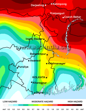
Seismic Map of West Bengal
Important Links To Download
-
Report On Earthquake in Sikkim-Nepal Border 2011
-